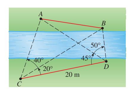
Stewart Precalc 6e Chapter 6 Focus on Modeling: Mapping a Town

8 questions

--:--
0 / 8
Stewart Precalc 6e Chapter 6 Focus on Modeling: Mapping a Town 0/8
1 Modeling - Completing the Map · Level 3
Completing the Map: Find the distance between the church and City Hall. (Refer to Figure 1, which shows a rough sketch of the town with the single measured distance of \(0.86\) mi between City Hall and the first bridge, plus all the relevant measured angles.)
2 Modeling - Completing the Map · Level 3
Completing the Map: Find the distance between the fire hall and the school. (You will need to find other distances first.)
3 Modeling - Determining a Distance Across a River · Level 3
Determining a Distance: A surveyor on one side of a river wishes to find the distance between points \(A\) and \(B\) on the opposite side of the river. On her side, she chooses points \(C\) and \(D\), which are \(20\) m apart, and measures the angles shown in the figure below. Find the distance between \(A\) and \(B\).
question image
4 Modeling - Height of a Cliff · Level 4
Height of a Cliff: To measure the height of an inaccessible cliff on the opposite side of a river, a surveyor makes the measurements shown in the figure at the left. Find the height of the cliff.
question image
5 Modeling - Height of a Mountain (Two Formulas) · Level 4
Height of a Mountain: To calculate the height \(h\) of a mountain, angles \(\alpha\), \(\beta\), and distance \(d\) are measured, as shown in the figure below. (a) Show that \(h = \dfrac{d}{\cot \alpha - \cot \beta}\). (b) Show that \(h = d \dfrac{\sin \alpha \sin \beta}{\sin(\beta - \alpha)}\). (c) Use the formulas from parts (a) and (b) to find the height of a mountain if \(\alpha = 25^{\circ}\), \(\beta = 29^{\circ}\), and \(d = 800\) ft. Do you get the same answer from each formula?
question image
6 Modeling - Distance Between Two Landmarks · Level 4
Determining a Distance: A surveyor has determined that a mountain is \(2430\) ft high. From the top of the mountain he measures the angles of depression to two landmarks at the base of the mountain and finds them to be \(42^{\circ}\) and \(39^{\circ}\). (Observe that these are the same as the angles of elevation from the landmarks as shown in the figure at the left.) The angle between the lines of sight to the landmarks is \(68^{\circ}\). Calculate the distance between the two landmarks.
question image
7 Modeling - Surveying Adjacent Building Lots · Level 4
Surveying Building Lots: A surveyor surveys two adjacent lots and makes the following rough sketch showing his measurements. Calculate all the distances shown in the figure, and use your result to draw an accurate map of the two lots.
question image
8 Modeling - Research Report · Level 2
Great Survey of India: The Great Trigonometric Survey of India was one of the most massive mapping projects ever undertaken (see the margin note on page 472). Do some research at your library or on the Internet to learn more about the Survey, and write a report on your findings.
question image

Answered: 0 / 8