Exam Complete
|
Stewart Precalc 6e Chapter 6 Focus on Modeling: Mapping a Town
0.0%
0/8
Results by Question
1
Modeling - Completing the Map
Error Rate 100%
Wrong
Completing the Map: Find the distance between the church and City Hall. (Refer to Figure 1, which shows a rough sketch of the town with the single measured distance of \(0.86\) mi between City Hall and the first bridge, plus all the relevant measured angles.)
(No answer submitted)
Answer
Apply the Law of Sines through the chain of triangles in Figure 1 that connects the known \(0.86\) mi side to the triangle containing the church and City Hall.
Compare with the answer above and grade yourself:
Explanation
From the worked example in the text, the bank-to-first-bridge distance is \(x \approx 1.32\) mi (obtained from \(\dfrac{x}{\sin 50^{\circ}} = \dfrac{0.86}{\sin 30^{\circ}}\)) and the bank-to-cliff distance is \(y \approx 1.55\) mi. Continue applying the Law of Sines \(\dfrac{a}{\sin A} = \dfrac{b}{\sin B}\) in each successive triangle along a path from the bank (or another known landmark) toward the church, propagating computed sides into adjacent triangles, until the side joining the church and City Hall is the unknown side of a triangle whose other elements are now known.
2
Modeling - Completing the Map
Error Rate 100%
Wrong
Completing the Map: Find the distance between the fire hall and the school. (You will need to find other distances first.)
(No answer submitted)
Answer
Apply the Law of Sines repeatedly through Figure 1, computing intermediate distances starting from the \(0.86\) mi baseline, until the triangle containing both the fire hall and the school is solvable.
Compare with the answer above and grade yourself:
Explanation
Trace a path of triangles from the known \(0.86\) mi side between City Hall and the first bridge to a triangle that contains both the fire hall and the school. In each triangle along the path, apply \(\dfrac{a}{\sin A} = \dfrac{b}{\sin B}\) to obtain an unknown side from a side that has already been computed plus the measured angles. The last application of the Law of Sines (in the triangle that includes both the fire hall and the school) yields the desired fire-hall-to-school distance.
3
Modeling - Determining a Distance Across a River
Error Rate 100%
Wrong
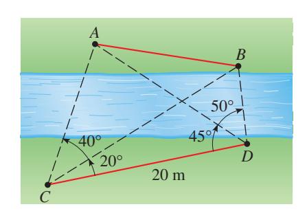
Determining a Distance: A surveyor on one side of a river wishes to find the distance between points \(A\) and \(B\) on the opposite side of the river. On her side, she chooses points \(C\) and \(D\), which are \(20\) m apart, and measures the angles shown in the figure below. Find the distance between \(A\) and \(B\).
(No answer submitted)
Answer
Apply the Law of Sines to triangle \(A C D\) to find \(A C\), and to triangle \(B C D\) to find \(B C\). Then apply the Law of Cosines to triangle \(A B C\), using the angle at \(C\) between \(C A\) and \(C B\), to obtain \(A B\).
Compare with the answer above and grade yourself:
Explanation
In triangle \(A C D\), the side \(C D = 20\) m is known, together with the angle at \(C\) (between \(C D\) and \(C A\)) and the angle at \(D\) (between \(D C\) and \(D A\)); the third angle at \(A\) is \(180^{\circ}\) minus those two. By the Law of Sines, \(\dfrac{A C}{\sin \angle A D C} = \dfrac{20}{\sin \angle C A D}\), which gives \(A C\). The same procedure in triangle \(B C D\) gives \(B C\). The angle at \(C\) in triangle \(A B C\) is the (signed) difference of the two angles measured at \(C\), and by the Law of Cosines \((A B)^2 = (A C)^2 + (B C)^2 - 2 \cdot A C \cdot B C \cdot \cos(\angle A C B)\). Taking the square root yields \(A B\).
4
Modeling - Height of a Cliff
Error Rate 100%
Wrong
Height of a Cliff: To measure the height of an inaccessible cliff on the opposite side of a river, a surveyor makes the measurements shown in the figure at the left. Find the height of the cliff.

(No answer submitted)
Answer
Form the triangle whose vertices are the two surveyor stations and the top of the cliff. Apply the Law of Sines to find the slant distance from one station to the top, then multiply by the sine of the angle of elevation from that station to obtain the cliff height.
Compare with the answer above and grade yourself:
Explanation
Let stations \(A\) and \(B\) on the near bank be separated by the measured baseline, and let \(C\) be the top of the cliff. The angles of elevation from \(A\) and from \(B\) to \(C\) are given. In the triangle \(A B C\) (in the plane that contains the baseline and the cliff top), the interior angles can be determined from the elevation angles and the baseline geometry. By the Law of Sines, \(\dfrac{A C}{\sin \angle A B C} = \dfrac{A B}{\sin \angle A C B}\), giving the slant distance \(A C\). The height of the cliff is \(h = A C \cdot \sin(\theta_A)\), where \(\theta_A\) is the angle of elevation from station \(A\) to the cliff top.
5
Modeling - Height of a Mountain (Two Formulas)
Error Rate 100%
Wrong
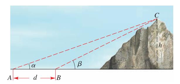
Height of a Mountain: To calculate the height \(h\) of a mountain, angles \(\alpha\), \(\beta\), and distance \(d\) are measured, as shown in the figure below. (a) Show that \(h = \dfrac{d}{\cot \alpha - \cot \beta}\). (b) Show that \(h = d \dfrac{\sin \alpha \sin \beta}{\sin(\beta - \alpha)}\). (c) Use the formulas from parts (a) and (b) to find the height of a mountain if \(\alpha = 25^{\circ}\), \(\beta = 29^{\circ}\), and \(d = 800\) ft. Do you get the same answer from each formula?
(No answer submitted)
Answer
(a) Derived from two right-triangle relations and subtracting. (b) Equivalent to (a) via a sum-to-product identity. (c) Both formulas yield \(h \approx 2349\) ft.
Compare with the answer above and grade yourself:
Explanation
(a) Let \(x\) be the horizontal distance from the closer observation point to the foot of the mountain, so the farther point is at horizontal distance \(x + d\). From the two right triangles formed, \(\tan \beta = \dfrac{h}{x}\) and \(\tan \alpha = \dfrac{h}{x + d}\), hence \(x = h \cot \beta\) and \(x + d = h \cot \alpha\). Subtracting gives \(d = h(\cot \alpha - \cot \beta)\), so \(h = \dfrac{d}{\cot \alpha - \cot \beta}\). (b) Combining the cotangents: \(\cot \alpha - \cot \beta = \dfrac{\cos \alpha}{\sin \alpha} - \dfrac{\cos \beta}{\sin \beta} = \dfrac{\cos \alpha \sin \beta - \sin \alpha \cos \beta}{\sin \alpha \sin \beta} = \dfrac{\sin(\beta - \alpha)}{\sin \alpha \sin \beta}\). Substituting into the result of part (a) gives \(h = d \dfrac{\sin \alpha \sin \beta}{\sin(\beta - \alpha)}\). (c) With \(\alpha = 25^{\circ}\), \(\beta = 29^{\circ}\), \(d = 800\) ft: \(\cot 25^{\circ} \approx 2.1445\) and \(\cot 29^{\circ} \approx 1.8040\), so \(\cot 25^{\circ} - \cot 29^{\circ} \approx 0.3405\) and \(h \approx \dfrac{800}{0.3405} \approx 2349\) ft. Using formula (b): \(\sin 25^{\circ} \approx 0.4226\), \(\sin 29^{\circ} \approx 0.4848\), \(\sin 4^{\circ} \approx 0.0698\), so \(h \approx 800 \cdot \dfrac{0.4226 \cdot 0.4848}{0.0698} \approx 2349\) ft. The two formulas are algebraically equivalent, so they yield the same height (about \(2349\) ft, to within rounding).
6
Modeling - Distance Between Two Landmarks
Error Rate 100%
Wrong
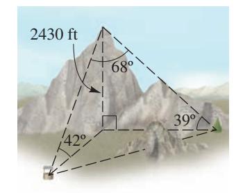
Determining a Distance: A surveyor has determined that a mountain is \(2430\) ft high. From the top of the mountain he measures the angles of depression to two landmarks at the base of the mountain and finds them to be \(42^{\circ}\) and \(39^{\circ}\). (Observe that these are the same as the angles of elevation from the landmarks as shown in the figure at the left.) The angle between the lines of sight to the landmarks is \(68^{\circ}\). Calculate the distance between the two landmarks.
(No answer submitted)
Answer
The distance between the two landmarks is approximately \(4194\) ft.
Compare with the answer above and grade yourself:
Explanation
Let \(T\) denote the top of the mountain, and let \(A\) and \(B\) be the two landmarks at the base. The slant distance from \(T\) to \(A\) satisfies \(\sin 42^{\circ} = \dfrac{2430}{T A}\), so \(T A = \dfrac{2430}{\sin 42^{\circ}} \approx \dfrac{2430}{0.6691} \approx 3631.7\) ft. Similarly, \(T B = \dfrac{2430}{\sin 39^{\circ}} \approx \dfrac{2430}{0.6293} \approx 3861.6\) ft. The angle at \(T\) between the sight lines \(T A\) and \(T B\) is \(68^{\circ}\). Applying the Law of Cosines to triangle \(T A B\): \((A B)^2 = (T A)^2 + (T B)^2 - 2 \cdot T A \cdot T B \cdot \cos 68^{\circ} \approx 3631.7^2 + 3861.6^2 - 2 (3631.7)(3861.6)(0.3746) \approx 13189000 + 14912000 - 10510000 \approx 17591000\). Therefore \(A B \approx 4194\) ft.
7
Modeling - Surveying Adjacent Building Lots
Error Rate 100%
Wrong
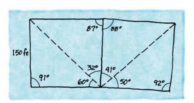
Surveying Building Lots: A surveyor surveys two adjacent lots and makes the following rough sketch showing his measurements. Calculate all the distances shown in the figure, and use your result to draw an accurate map of the two lots.
(No answer submitted)
Answer
Apply the Law of Sines and the Law of Cosines to each triangle (or sub-triangle) of the sketch in turn, starting with a triangle whose data is fully determined, and propagate to adjacent triangles via shared sides. Once every side is known, plot the polygon to scale.
Compare with the answer above and grade yourself:
Explanation
Identify each triangle in the sketch. A triangle with one known side and two known angles is solved by the Law of Sines \(\dfrac{a}{\sin A} = \dfrac{b}{\sin B} = \dfrac{c}{\sin C}\); a triangle with two known sides and the included angle is solved by the Law of Cosines \(c^2 = a^2 + b^2 - 2 a b \cos C\). Solve one triangle at a time, using each computed side as input to the next neighboring triangle through their shared edge. After all sides have been determined, scale them onto graph paper to produce an accurate map of the two adjacent lots.
8
Modeling - Research Report
Error Rate 100%
Wrong
Great Survey of India: The Great Trigonometric Survey of India was one of the most massive mapping projects ever undertaken (see the margin note on page 472). Do some research at your library or on the Internet to learn more about the Survey, and write a report on your findings.

(No answer submitted)
Answer
Open-ended research project. A complete report should cover the historical timeline (begun in \(1802\)), the principal leaders (William Lambton and George Everest), the methodology (triangulation using massive theodolites and carefully measured baselines), the corrections required (atmospheric refraction and Earth's curvature), and notable results (including the height measurement of Peak XV, later named Mount Everest).
Compare with the answer above and grade yourself:
Explanation
The Great Trigonometric Survey was a multi-decade scientific project to map the Indian subcontinent with unprecedented precision. It began in \(1802\) under William Lambton and was continued from \(1823\) by George Everest. The team carefully measured a long initial baseline and then extended a chain of triangles across the country, using massive theodolites and applying corrections for atmospheric refraction and the curvature of the Earth. Among its most famous results is the determination of the height of Peak XV (later renamed Mount Everest), which the Survey computed to be approximately \(29000\) ft.